

 Click to embiggen
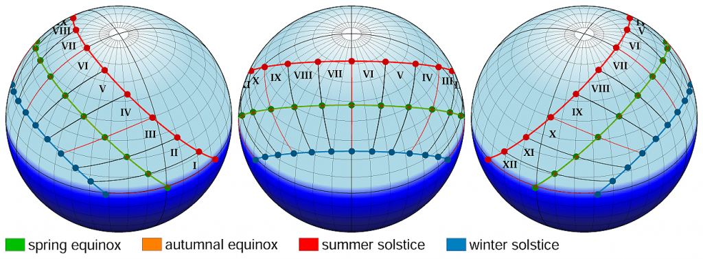
A chart of the sky, showing how Ancient Romans measured time in the year 8 CE – meaning, what hora it was when the sun was at a specific point in the sky at the equinoxes and at the solstices.
Here’s how the creator describes what was going on:
The paths of the sun on the sky during equinoxes and solstices AD 8 at Forum Romanum 41.892426°N 12.485167°E, horizontal coordinate system. The numbers indicate Roman horae (hora prima, secunda, tertia etc.).
Sun azimuths and elevations are computed. Sunrise and sunset times are used as boundaries of day and night. Many sources however are ambiguous because of confusing terms sunrise with dusk and sunset with dawn. This is important, because times of dusk and dawn differ significantly from times of sunrise and sunset. The semidiameter of the sun and atmospheric refraction are taken into account. Equinoxes and solstices are computed too, not set by Romans.
Sunrise and sunset times, sun azimuths and altitudes, dates and times of equinoxes and solstices were calculated using algorithms from:
Jean Meeus, Astronomical algorithms, Second English Edition, Willmann-Bell, Inc., Richmond, Virginia, 1998, With corrections as of August 10, 2009, ISBN 0-943396-61-1.
There is an online calculator also based on Astronomical Algorithms, by Jean Meeus, computing sunrise and sunset times, sun azimuths and elevations: http://www.esrl.noaa.gov/gmd/grad/solcalc/ NOAA Solar Calculator (Gregorian calendar) however calculations for this image are based directly on this Meeus’s book.The map was created using the Generic Mapping Tools, GMT, version 5.1.2.